


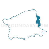
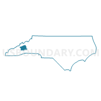
Voting District 36.1, Buncombe County, North Carolina
About
Outline

Summary
| Unique Area Identifier | 639427 |
| Name | Voting District 36.1 |
| County | Buncombe County |
| State | North Carolina |
| Area (square miles) | 25.39 |
| Land Area (square miles) | 25.13 |
| Water Area (square miles) | 0.26 |
| % of Land Area | 98.98 |
| % of Water Area | 1.02 |
| Latitude of the Internal Point | 35.64259830 |
| Longtitude of the Internal Point | -82.32674030 |
Maps

Graphs
Select a template below for downloading or customizing gragh for Voting District 36.1, Buncombe County, North Carolina


Neighbors
Neighoring Voting District (by Name) Neighboring Voting District on the Map
- Voting District 09 SOU, Yancey County, NC
- Voting District 10 PEN, Yancey County, NC
- Voting District 32.1, Buncombe County, NC
- Voting District 33.2, Buncombe County, NC
- Voting District 33.3, Buncombe County, NC
- Voting District 35.1, Buncombe County, NC
- Voting District 37.1, Buncombe County, NC
- Voting District 50.1, Buncombe County, NC
- Voting District FORT-1, McDowell County, NC
- Voting District FORT-2, McDowell County, NC
Top 10 Neighboring County Subdivision (by Population) Neighboring County Subdivision on the Map
- Black Mountain township, Buncombe County, NC (13,416)
- Old Fort township, McDowell County, NC (4,122)
- Ivy township, Buncombe County, NC (3,569)
- South Toe township, Yancey County, NC (2,344)
- Broad River township, Buncombe County, NC (1,763)
- Pensacola township, Yancey County, NC (625)
Top 10 Neighboring Place (by Population) Neighboring Place on the Map
Top 10 Neighboring Unified School District (by Population) Neighboring Unified School District on the Map
- Buncombe County Schools, NC (199,157)
- McDowell County Schools, NC (44,996)
- Yancey County Schools, NC (17,818)
Top 10 Neighboring State Legislative District Lower Chamber (by Population) Neighboring State Legislative District Lower Chamber on the Map
- State House District 115, NC (79,480)
- State House District 114, NC (73,570)
- State House District 85, NC (71,855)
- State House District 84, NC (65,274)
Top 10 Neighboring State Legislative District Upper Chamber (by Population) Neighboring State Legislative District Upper Chamber on the Map
- State Senate District 48, NC (193,127)
- State Senate District 49, NC (172,441)
- State Senate District 47, NC (168,288)
Top 10 Neighboring 111th Congressional District (by Population) Neighboring 111th Congressional District on the Map
Top 10 Neighboring Census Tract (by Population) Neighboring Census Tract on the Map
- Census Tract 31.04, Buncombe County, NC (5,899)
- Census Tract 31.02, Buncombe County, NC (5,663)
- Census Tract 9707, McDowell County, NC (4,380)
- Census Tract 9708, McDowell County, NC (4,227)
- Census Tract 9601.01, Yancey County, NC (3,954)
- Census Tract 29, Buncombe County, NC (3,551)
- Census Tract 9603, Yancey County, NC (3,019)
- Census Tract 31.03, Buncombe County, NC (1,879)